1.07 kilometres - 15 minutes
 Wascana is a centre of activity. Whether participating in the Canada Day celebrations or the opening of the Legislative Assembly, enjoying quiet walks along the lake shore or a tour through the Royal Saskatchewan Museum, attending a family picnic or a multimedia production at the Conexus Arts Centre, people are always using and enjoying Wascana Centre.
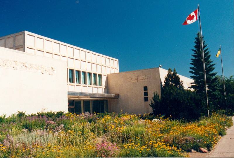
The walk begins in front of the Royal Saskatchewan Museum which was designed by Mr. E.J. McCudden. The 137 metre long frieze along the top of the building was carved in Tyndall stone by Mr. B. Garnier and shows more than 300 animals native to Saskatchewan. The museum was dedicated to the pioneers of Saskatchewan by Governor General Vincent Massey in 1955.
Saskatchewan's geologic and prehistoric history is interpreted through exhibits in the Earth Sciences Gallery. Tour life-size dioramas and interactive displays to discover how nature maintains a dynamic balance and how human “footprints” are upsetting that balance. The Paleopit is an interactive gallery that permits children and adults to experience hands on activities with computers, fossils, minerals, microscopes and much more.
The museum is also home to "Megamunch", a half-size robotic model of a Tyrannosaurus Rex. See Saskatchewan from another perspective in the First Nations Gallery. Trace the history and culture of Saskatchewan over the past 10,000 years through breathtaking artwork and artifacts. The Life Sciences Gallery showcases Saskatchewan ecoregions and wildlife in a global setting. A new addition to the museum came in 2019 with the unveiling of Scotty the T-Rex. Scotty is the largest known Tyrannosaurus rex in the world, estimated to weigh in at a whopping 19,555 lbs!- To the west of the museum is Albert Street, the western boundary of Wascana Centre. While walking south you will see in the distance the Albert Memorial Bridge. It was officially dedicated on November 10, 1930 to the men who lost their lives in the First World War. The bridge was refurbished, and rededicated by city officials on October 2, 1988. In 1999 it was honoured as an historic site by the Civil Engineering Society.
- Just before the bridge is a path to your left that will bring you to Speakers' Corner. The features that make up the corner symbolize the historical development of the democratic ideals of free speech and assembly. The large gas lamps at the entrance were brought from Hyde Park and stood near Speakers' Corner in London, England. The columns surrounding the central podium were from the old Regina City Hall and symbolize free speech at the municipal level. The official opening and dedication ceremonies for Speakers' Corner were performed by the late Lord Mountbatten. Four pioneers of Saskatchewan government are honoured here with memorials: James Ross, Nicholas Davin, Frederick Haultain and Charles Dunning.
- The lake deepening project in 2004 generated a major change in the footprint of the lake alongside Albert Street. The development of a pedestrian bridge has helped to re-direct foot traffic away from the road onto a safer, quieter walkway. The 16 pedestals set along the walkway provide interpretive information spanning more than 100 years, from the first settlers' arrival in the area to the lake deepening project. The walkway's shore line was refurbished using pre-cast concrete.
The view of the Legislative Building from the north shore is truly impressive. Completed in 1912, the Legislative Building was designed by Edward and William Sutherland Maxwell of Montreal. When the site was chosen in 1906, flat prairie grasslands were all that could be seen in any direction. The vision, aspiration and determination of the first urban planners are truly admirable.
The spray fountain you see was put in as part of the 2004 lake revitalization project. This spray fountain and 13 other submerged aeration units help to oxygenate the water which in turn helps to control algae growth in the lake.
You are now in the area formally known as Wascana Park. In 1906 the Province of Saskatchewan gave these 44 acres of land located on the north shore of Wascana Lake to the City of Regina for the development of a public park. By the 1920's the area you are walking through was regularly used for recreational activities. Wascana Bandstand, located to your left, can be booked for public and private functions.- Just north of the walking path is the Honouring Tree. The Honouring Tree is a public art and diversity legacy community project initiated by the Saskatchewan African Canadian Heritage Museum board and membership as part of the 2010 Centennial Celebrations to commemorate the 1910 settlement of people with African ancestry in Regina (and Saskatchewan as a whole). It is a symbol of life, legacy and diversity and it will become a symbol of life, legacy and diversity through which we remember and honour our past, our heritage and contributions and the good and not so good times. The Honouring Tree was installed in Wascana Centre near the Royal Saskatchewan Museum on August 31, 2011.
- If you were to keep walking east on the path you will find the Links Between Capitals, which is a small seating/viewing area that was incorporated into the Wascana Park Promenade Landscape Repair. This project includes the concrete retaining wall.
The seating area is dedicated to the relationship between the Federal and Provincial Capitals of Canada and Saskatchewan. The project was funded by Wascana Centre and the National Capital Commission (NCC) in Ottawa. NCC provided the two benches, two lights and a litter container as a component of their provincial outreach program. They provided the same park furnishings as used by the NCC on Confederation Boulevard in Ottawa.
Further east up the walking past you will come across the Regina Boat Club Monument. The Regina Boat Club was established in 1907 and held the distinction of being the furthest inland rowing club in North America and the British Commonwealth. In 1912 the Regina cyclone demolished their clubhouse, which was immediately rebuilt. In 1947 the club moved to Willow Island where it stayed until it was disbanded in 1962. Wascana Centre erected this monument, located on the Northwest area of the centre, in August 1971.
As you walk up the incline the path takes you past a Wascana play area, one of four in Wascana Centre. The Wascana Park Playground was retrofitted in 1990 with the construction of a shelter over the former wading pool. Further along the path is Wascana Pool which opened in 1947 after swimming in the lake was banned.
- East of the pool across the street is a sunken parking lot. The lot was designed by the first master planner of Wascana Centre, Minoru Yamasaki. It is 1.2 metres below ground level and surrounded by foliage. Cars are therefore screened from view and the natural image of the Centre is kept intact. The dirt that was excavated from this site was used to build Goose Hill east of Broad Street. This walk goes through one of the oldest areas in Wascana Centre. As early as 1906, when the site for the Saskatchewan Legislative Building was chosen, the north shore of Wascana Creek had already been designated as a public park by the City of Regina. The Mawson Plan of 1913 was prepared by landscape architect Thomas Mawson. His plan assured that the Legislative area and the north shore would be developed to create an oasis of greenery on the flat prairie. The establishment of Wascana Centre in 1962 along with the approval of Minoru Yamasaki's 100 year plan has guaranteed that the 2300 acres /930 hectares of land and water in Wascana Centre will continue to be a green oasis in the heart of Regina.
with our newsletter