1.75 kilometres - 30 minutes
 This walk aims to give an appreciation of the work done by human hands to build a unique setting in the Queen City, to develop the seat of government, to enlarge educational opportunities, to advance cultural arts, to improve recreational facilities, and to conserve the environment. Please note: The Culliton Centre was demolished this winter which has affected the numbering of this tour. Points 5 - 13 are now one number lower. An updated map will be uploaded shortly.
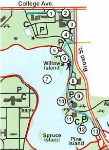
- These buildings are a part of the University of Regina. The first building as you walk east is Darke Hall. It opened in 1929 and for many years was the major centre for the performing arts in Regina until the Conexus Arts Centre was opened in 1970. Darke Hall is currently undergoing extensive renovations and when finished will once again resonate to the sounds of musical and theatrical productions. The restoration continues west of Darke Hall where the Gallery Building and Conservatory once stood. The College Building is the third building and contains the offices of University Extension which offers Certificate Programs and Off-Campus Degree Credit Programs.
- The final building along this portion of College Avenue was known as the old Regina Normal School, but has been refurbished and now houses the CanSask Sound Stage. When first established in 1911 by the Methodist Church of Canada, the Normal School was used for training Saskatchewan teachers. By 1929, a women's residence and a gymnasium were completed. The depression of the 1930's brought with it financial constraints and the church then transferred the college to the University of Regina campus. It was used by the University of Regina Fine Arts Department until new facilities at the main campus led to the building's closure. In the mid 1990's, the Government of Saskatchewan, the City of Regina, and the Saskatchewan Motion Picture Industry Association went into partnership and redesigned the building so that it has 4 sound stages which have the capacity to film feature length movies, television sitcoms or fulfill any other needs of the media industry.
Continuing south along Broad Street you will pass by the Canadian Broadcasting Corporation Building, a complete production centre for both French and English television and radio. The building has been designed to incorporate advanced techniques in design and equipment for use in its nine radio and three television studios. You can also see that the CBC is connected to the CanSask Sound Stage whereby the two facilities have access to each other's amenities. The CBC building is of architectural interest because of its glassed-in foyer. It was designed to preserve a cone of vision to the Legislative Dome as one drives south on Broad Street.
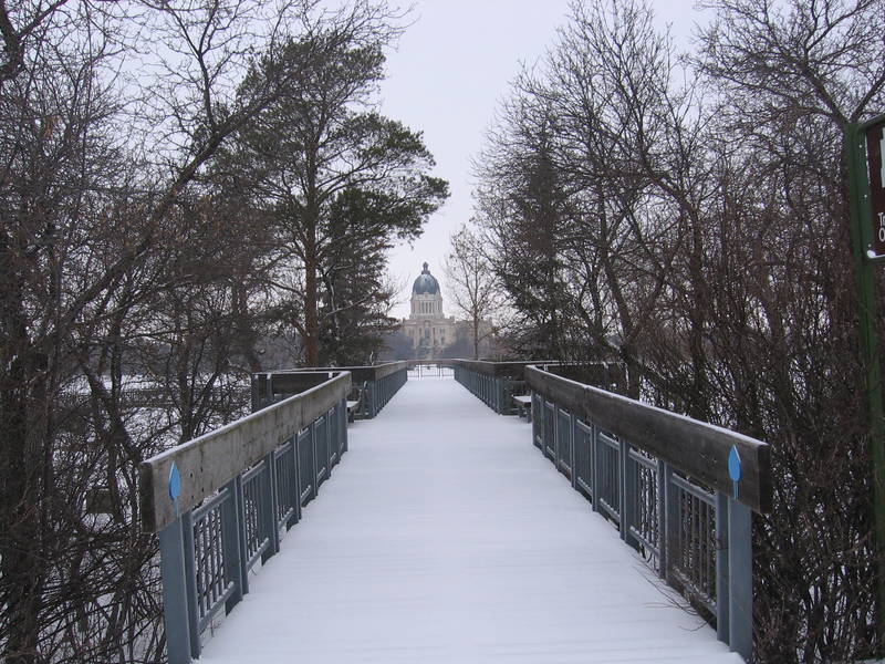
The concrete path southwest of the CBC building leads to the Willow Island Overlook. This structure was completed in 1967. Its design is functional, with the lowest level being the boat dock for the ferry which provides public transportation to and from Willow Island. A pump house for the irrigation of the north shore is built into the second level. The third level is an observation deck. Stand in the middle of the top deck and listen to the echo when you speak!
- Willow Island can be seen across the water from the overlook. The island was originally built during the 1930's and was expanded during the lake deepening project in 2004. Willow Island was originally used by the Regina Boat Club which was disbanded in 1962. The newly established Wascana Centre Authority decided to make the island available to the public for group picnics. Barbecue sites, picnic tables, washrooms and sheltered areas were built and are available to the public. Group reservations can be made by contacting Wascana Centre.
- The early history of this man-made lake must be appreciated. In the 1880's Wascana Creek was dammed by the local settlers so the reservoir could be used to water livestock. In 1908 a bridge and dam were built on Albert Street to hold back the waters of Wascana Creek. A second bridge on Broad Street was constructed in the same year to enclose the area from Albert to Broad Street to form a water reservoir in front of the newly constructed Legislative Building. By the late 1920's, the water level in the reservoir was so low that most water based recreational activities were abandoned. The depression of the 1930's left many people unemployed and prompted the government to design a relief program to provide work for more than 2100 men. Using hand tools and horse-drawn wagons, these men dredged and widened Wascana Lake and built two islands, Willow and Spruce Islands. In 2004 Wascana Lake was once again deepened and two more islands, Pine and Pelican Islands, were formed from the excavated soil.
- The walkway continues south along the lake. The HMCS Queen Building across the road to the east was included within Wascana Centre when the Centre was formed in 1962. Although the building is on federal government land and not bound by provincial statute, arrangements have been made to allow Wascana Centre to develop and maintain the landscaping around the building so as to unify it with the rest of the Centre. The flagpole was once the mast of a real ship.
- South of the Queen Building is Wascana Place, the headquarters for the Provincial Capital Commission. The building was opened April 1, 1982, marking twenty years of progress and development within Wascana Centre under the Authority. Maps and information on Wascana Centre and the city are available here as well as public exhibits that describe the history and future of Wascana Centre in more detail. The upper levels provide office space, an observation deck, and right next to the entrance is our visitor information kiosk. Come in and visit us!
- West from Wascana Place is Trafalgar Overlook and Pond, so named because of the view of Trafalgar Fountain across the lake to the west. The overlook site design received a citation for outstanding achievement from the Canadian Society of Landscape Architects in 1989.
- On your right is the Wascana Racing Canoe Club storage facility. Built in 1996 and expanded in 2005, it replaces the temporary trailers and sheds that the club was using. The Wascana Racing Canoe Club holds numerous regattas on Wascana Lake that encompass different disciplines and all levels of athlete.
- The Wascana Marina was constructed for the 1975 Western Canada Summer Games. The Wascana Marina Building was officially opened May 15, 1981 to serve as a warm-up shelter in winter. In July 1986 it was altered to serve as a year round restaurant facility, The Willow. For the 2005 Canada Summer Games it was expanded to include larger storage facilities as well as year round washrooms/change rooms. The building was also renamed the Canada Games Wascana Lake Centre. It provides a launching site for the many canoes and sailboats found on Wascana Lake during the summer months.
- The Broad Street Bridge forms the western boundary to Wascana Waterfowl Park. In 2004 a bicycle path was constructed under the bridge allowing for an easier and safer continuation of the south shore trail. The lake area to the east of the bridge is left in a natural marsh state to provide a home for local and migrating waterfowl and small wildlife. Park naturalists ensure the health and safety of these birds and other wildlife.
with our newsletter